Bike into the future with Velosimulator 2.0
VR allows one to “experience” future cycling infrastructure and provides important insights in planning. Building the 3D model to enable this experience is now faster with the Velosimulator 2.0.
While cycling is an energy-efficient means of transport that promotes a healthy lifestyle, the lack of safe and continuous bicycle paths in Switzerland stands in the way of making cycling a means of transport in everyday life.
In the planning and redesign of road space, two-dimensional project plans are often not able to provide a complete picture of the spatial conditions of proposed plans. On the other hand, unlike conventional renderings, virtual reality (VR) offers the possibility not only to visualize the planned future, but also to immerse in the experience.
However, the generation of suitable 3D models of today's built environment for VR applications in planning presents a challenge, as they require 3D models with different levels of detail (LOD), the automated acquisition and generation of which has not been possible so far.
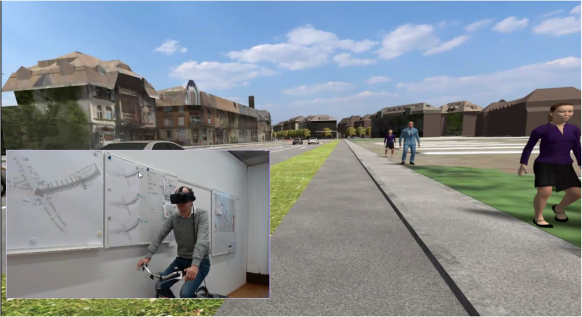
Michael Joos and Muhammad Salihin Bin Zaol-Kefli completed the Virtual Reality Velosimulator 2.0 project with Future Cities Laboratory alumni Prof. Alex Erath and Dr Michael van Eggermond at FHNW and team, which has made the time-consuming process of generating realistic VR models more efficient. The mobile acquisition of images using a backpack and the integration of a realistic 3D city model, a traffic simulation and a bike trainer, have enabled the automatic reconstruction of the street space in the form of a VR-compatible 3D model.
The project also aims to develop and test procedures that could combine the city models generated with 3D plans for future street space design in practice. Another goal of the project is to bring the software and hardware of the VR velo simulator developed at the Future Cities Laboratory—known as the “Bike to the Future” project by the Engaging Mobility team—up to the state of the art and to make it more modular.
The team used the redesign of the Burgernziel traffic circle in the city of Bern as a case study, as the city already had a 3D model of the entire city, as well as traffic simulation. The image data were acquired with the IGEO measuring backpack developed in the BIMAGE project at FHNW. After georeferencing, these data were used for the texturing of the existing city model and the automatic generation of a realistic 3D model.
The existing traffic simulation was created in combination with software that optimizes the flow of traffic signals.The traffic simulation created with VISSIM now also includes pedestrians in order to provide a realistic impression of the traffic situation. The 3D model of the road space, including curbs or elevations of sidewalks and waiting area for cars, is based on existing 2D plans. Additional 3D models, which were created according to common road features in Switzerland, increase the visual quality of the VR environment.
The two 3D models and the trajectories of the road users generated with the traffic simulation form the basis for generating the VR environment with the Unity software. To make the VR simulator easy to use, the team developed a simple game.
The team will present the bike simulator and the 360-degree videos created with the game engine at various events. In collaboration with the city of Bern, the team is also exploring how findings of this project can contribute to participatory planning and policy- and decision-making processes. Future research will be geared towards enabling direct communication between the traffic simulation and the VR engine to make the cycling experience more realistic.
external page Read about the development of the Velosimulator 2.0 here