Stakeholder engagement in land use modelling
Eduardo Gomes, Asst Prof (Adj) Markus Schlaepfer and co-authors describe how stakeholders can directly be engaged in the modelling and simulation process of future land developments.
Anticipating decisions and indicating alternative futures and their impacts to support policy-makers, is one of the biggest challenges of spatial planning. Land use management requires the capacity to incorporate the various purposes and needs of different stakeholders who are driven by different goals. For example, some are driven by economic incentives while others are interested in preserving the long-term ecological functions of their land.
Researchers external page Eduardo Gomes (former visiting PhD student within FCL’s Big Data Informed Urban Design and Governance project), external page Arnaud Banos, external page Patrícia Abrantes, external page Jorge Rocha, and Asst Prof (Adj) Markus Schläpfer explore the integration of spatial planning and complexity science in the paper external page "Future land use changes in a peri-urban context: Local stakeholder views" published in Science of the Total Environment. In the paper, they describe how to possibly engage stakeholders (from the land use planning, agriculture, and forest sectors) in the building and assessment of future land use and land cover change (LUCC) scenarios. Future LUCC assessment is one of the most relevant practices in the spatial planning process and has been increasingly applied to spatial planning instruments in the last few years.
The researchers selected the Torres Vedras Municipality, a peri-urban region near Lisbon, Portugal as case study. Torres Vedras has had a boom in population over the last few decades that has led to an increase of built-up surfaces resulting in the loss of natural and agricultural land. This has further led to economic and environmental imbalances as agriculture is a major contributor to the local and regional economy. Planners need to be prepared and more efficient policies are urgently needed to preserve natural areas and agricultural land.
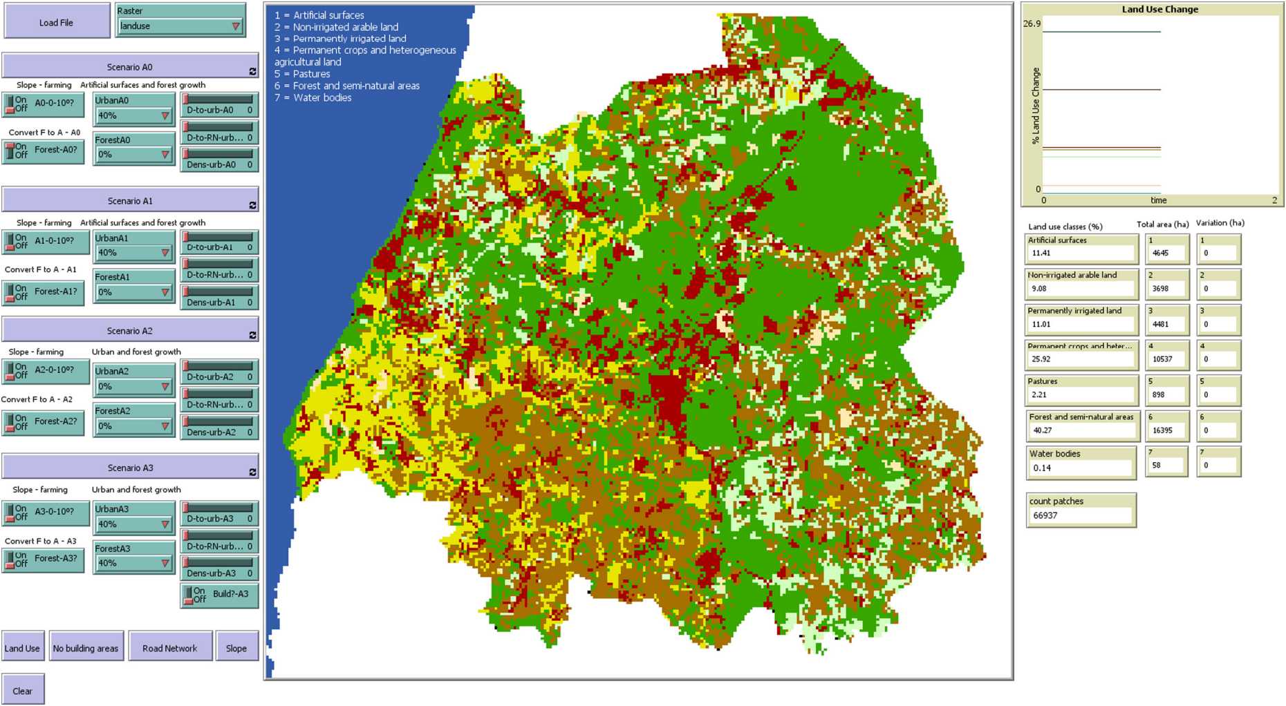
Mixed-methods (quantitative and qualitative) were used in their study by means of a participatory workshop to analyse LUCC model outcomes, based on farmer LUCC intentions, for the following scenarios: A0 - current social and economic trend (Business as Usual); A1 - regional food security; A2 - climate change; and B0 - farming under urban pressure.
This analysis allowed local stakeholders to develop and discuss their own views on the most plausible future LUCC for the following land use classes: artificial surfaces, non-irrigated arable land, permanently irrigated land, permanent crops and heterogeneous agricultural land, pastures, forest and semi-natural areas, and water bodies and wetlands. It also enabled the researchers to strengthen their relations with the stakeholders, encouraged knowledge sharing and the exchange of different points of view, and allowed researchers to see how stakeholders can play their part in the decision-making process.
Subsequently, the researchers spatialized these LUCC views into a Cellular Automata - Geographic Information Systems (GIS) hybrid model, identifying the most suitable land conversion areas. This model is referred to as the stakeholder-LUCC model. The stakeholder-LUCC model allows spatializing future LUCC, showing the outcomes both spatially and graphically.
Their work external page "Future land use changes in a peri-urban context: Local stakeholder views" was published in Science of the Total Environment.